Landmark products
Landmark Information Systems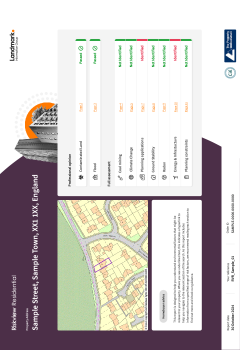
Overview
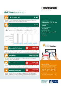
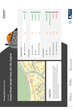
Riskview Residential is an All-In-One report that delivers its users with comprehensive environmental due diligence. It provides both a contaminated land liability risk assessment under Part 2A of the Environmental Protection Act (1990) as well as a flood risk assessment, which is reviewed by an Argyll Consultant if a high risk is identified. As it is all encompassing, it also provides a full review of ground stability, including coal, radon, energy and infrastructure projects and planning information.
Includes
Professional Opinion:
- Contaminated land liability assessment with ‘Professional Opinion’ for Part 2A of the EPA. Providing a clear report conclusion of Passed or Further Action to copy into the report on title. Includes Landmark’s innovative and ever expanding ‘Risk Assessed Land Register’ dataset to provide more passes early on
- Flood Risk - A clear report conclusion of Passed, Passed Moderate or Further Action with a ‘Professional Opinion’ to copy into the report on title. Assessment includes all key sources of flooding, flood defences as well as proximity to and elevation above historic flood events and watercourses. The result is scrutinised by an Environmental Consultant if a high risk is identified
Full Assessment:
- Ground Stability: A detailed ground stability, subsidence and mining assessment to identify if a risk could exist, eliminating the need for a follow-on report.
- Climate change: a comprehensive assessment of key data sets to understand future risk from both physical & transition risk.
- Landmark’s, market-first, coal alert providing certification as to the results accuracy, where ‘no’ or ‘low’ risk is identified (backed by an in perpetuity £1m indemnity policy) and a full Landmark Coal report where necessary.
- Radon: An assessment of whether Radon could be an issue in the location
- Energy & Infrastructure: A detailed review of a wide variety of energy or transport projects contained within our Energy & Infrastructure Report. Search radius up to 4km search radius
- Planning: A review of core planning application data for the property and in the immediate surrounding area including planning constraints and local authority planning strategies which may affect the new owner’s ability to make certain changes to the property. Inc. large applications as polygons for the majority of the Great Britain.
Other Considerations
- Contaminated land, excess free remediation contribution of £250,000 – the market’s highest
- Free re-review service
- Flood Insurability Statement
When to use
For residential transactions where you require the most comprehensive due diligence and expert analysis on all key environmental risks including climate change. Delivering the highest level of accuracy and evaluation.
Please log in or register if you are interested in ordering this product.
Overview
Purchased together, RiskView and Landmark Planning provide full environmental due diligence for every transaction, protecting your clients investment and the reputation of your practice! This digital ‘bundle’ package provides homebuyer clients with online access to both environmental risk data and planning application data, via one single order.
1. RiskView Residential
RiskView Residential is an all-in-one environmental report, with the added bonus of a digital viewer for the home buyer. Provides concise and easy to interpret Contaminated Land, Flood, Ground Hazards and Energy & Infrastructure risk data, as well as interactive maps and further information for the buyer. RiskView Residential will include planning applications and planning constraints data, as standard.
RiskView Residential also now benefits from an increased remediation, from £100,000 to £250,000 which is the highest protection available in the market.
What's included?
- Front page risk summary and clear ‘next steps’
- Full desktop assessment of 4 environmental risks
- Landmark’s unique risk assessed land register data
- Contaminated Land excess free remediation contribution
- Landmark’s unique interactive viewer
- PI cover of £10 million
RiskView Residential is the only 'all in one' environmental report to automatically include a manual risk assessment where the data reveals a significant risk of flooding, resulting in far more flood passes. Uniquely, the height of the property is also considered in relation to possible flood events, resulting in a highly accurate risk result meaning that you get best practice due diligence with smoother, quicker transactions for you and your clients.
Simplified Guidance
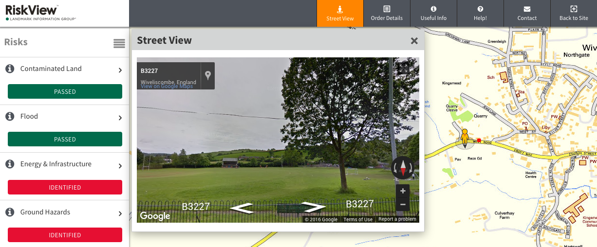
RiskView Residential includes an online viewing tool that’s accessible via links embedded within the PDF report. You can now present the environmental and planning information in the way your clients want to see it: quickly and online. Your clients simply click through to a unique interactive map where they can easily navigate around the property and understand any environmental risks and planning information (when purchased with a Plansearch Plus) at their leisure.
***Free report re-ordering service to support homebuyers facing lengthy transaction timescales***
Landmark is offering property lawyers the opportunity to re-order a fresh RiskView Residential report at a later stage of the transaction, for no additional fee. Click here for more details.
2. Landmark Planning
The Landmark Planning report will give your clients details on whether there are nearby planning applications that may impact the property as well as any types of development that are currently being carried out in the area.
Landmark Planning will uniquely display data of the majority of the UK’s large planning applications as polygons, providing a realistic understanding of the potential impact, both positive and negative, of a development.
What’s Included:
- Planning applications
- Land use designations
- Housing and neighbourhood demographics
- Amenities and education
- Rights of way
The Landmark Planning report includes the addition of useful ‘neighbourhood’ information; such as the location of telecoms masts, local footpaths, nearby schools and their performance, housing types and average prices, population demographics and local amenities. This will better inform your client, ensuring they are aware of planning decisions and socio-demographic knowledge within the surrounding area of their potential property.
The perfect combination
Each time a RiskView Residential environmental report is ordered alongside a Landmark Planning report, the environmental and planning application data will be added automatically to an online, interactive map viewer, which helps to visually ‘bring to life’ the findings. This means homeowners can instantly see where any potential environmental risks may be present within a 250m proximity of the property, in addition to active/pending/approved residential and commercial planning applications up to a 750m radius via the mapped viewer.
View our product card and sample report for full details.
Please log in or register if you are interested in ordering this product.
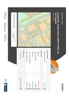
Sitecheck Assess is Landmark’s core commercial environmental risk report. It provides a contaminated land liability risk assessment under Part 2A of the Environmental Protection Act (1990). Alongside this the report provides full assessments of data to confirm whether flood risk, energy & infrastructure projects, ground stability, radon or planning constraints could also be an issue at the property. It also includes an alert assessment to determine if coal mining could affect the property.
Includes
Professional Opinion:
- Contaminated land liability assessment for Part 2A of the EPA providing a clear report conclusion of Passed or Further Action. Including Landmark’s innovative and ever expanding ‘Risk Assessed Land Register’ dataset to provide more passes early on
Full Assessment:
- Flood Risk: An assessment of Landmark’s comprehensive suite of flood data to identify whether flooding could affect the property.
- Ground Stability: Full assessment of our ground stability and subsidence data, to identify if a risk could exist.
- Radon: An assessment of whether Radon could be an issue in the location
- Energy & Infrastructure: Full assessment of our energy and infrastructure development data, negating the need for a follow-on report
- Planning constraints are highlighted
Alert Assessment:
- Coal risk - A market-first, ‘No search’ certificate. Alongside and integral to the Coal Screening Data Layer is Landmark’s certification as to the result’s accuracy, where ‘No’ or ‘Low’ risk is identified. Landmark’s certification is backed by a £1M indemnity policy.
When to use
Use for commercial property transaction including purchase & leases. Where there is planned development or change of use, we recommend using SiteSolutions commercial or combined.
Please log in or register if you are interested in ordering this product.
Overview
Homecheck Residential provides a contaminated land liability risk assessment under Part 2A of the Environmental Protection Act (1990). Alongside this, the report provides a full assessment for ground stability and radon as well as an alert assessment, where relevant to the property, for flood risk, coal mining, planning and energy & infrastructure and which will prompt you to investigate further.
This report contains:
Professional Opinion:
- Contaminated land liability assessment for Part 2A of the Environmental Protection Act (1990) that meets the needs of the Law Society’s Contaminated Land Practice Note. It also includes Landmark’s innovative and ever expanding ‘Risk Assessed Land Register’ dataset to provide more passes early on.
Full Assessment:
- Ground Stability - Provides a full assessment of ground stability and subsidence data, negating the need for a follow-on report.
- Radon - An assessment of whether Radon could be an issue in the location
Alert Assessment:
- Flood Risk - A high-level summary of any flood hazards to prompt whether to investigate further.
- Coal Risk - A market-first, ‘No search’ certificate. Alongside and integral to the Coal Screening Data Layer is Landmark’s certification as to the result’s accuracy, where ‘No’ or ‘Low’ risk is identified. Landmark’s certification is backed by a £1M indemnity policy.
- Planning – an alert assessment making you aware of potential changes to the surrounding environment that may impact intrinsic enjoyment of the property. In additional you will receive information on Planning constraints.
- Energy & Infrastructure – an assessment to determine if energy and infrastructure developments could impact the property, and to prompt further investigation.
Please log in or register if you are interested in ordering this product.

Overview
Envirosearch is Landmark’s core environmental risk report. It provides a contaminated land liability risk assessment under Part 2A of the Environmental Protection Act (1990). Alongside this the report provides full assessments of data to confirm whether flood risk, energy & infrastructure projects, ground stability or radon could also be an issue at the property. This report now also comes equipped with the newly added climate change module, and is our recommended report for Mining and Subsidence.
It also includes alert assessments to determine if coal mining and planning applications could affect the property.
This report contains:
Professional Opinion:
- Contaminated land liability assessment for Part 2A of the EPA providing a clear report conclusion of Passed or Further Action. Including Landmark’s innovative and ever expanding ‘Risk Assessed Land Register’ dataset to provide more passes early on
Full Assessment:
- Flood Risk: An assessment of Landmark’s comprehensive suite of flood data to identify whether flooding could affect the property.
- Climate change: a comprehensive assessment of key data sets to understand future risk from both physical & transition risk
- Ground Stability: Full assessment of our ground stability and subsidence data, negating the need for a follow-on report
- Radon: An assessment of whether Radon could be an issue in the location
- Energy & Infrastructure: Full assessment of our energy and infrastructure development data, negating the need for a follow-on report
Alert Assessment:
- Coal risk - A market-first, ‘No search’ certificate. Alongside and integral to the Coal Screening Data Layer is Landmark’s certification as to the result’s accuracy, where ‘No’ or ‘Low’ risk is identified. Landmark’s certification is backed by a £1M indemnity policy.
- Planning – alert assessment making you aware of potential changes to the surrounding environment that may impact intrinsic enjoyment of the property. In additional you will receive information on planning constraints.
Other Considerations
- Contaminated land, excess free remediation contribution of £150,000
- Free re-review service
When to use
For Residential transactions when requiring a professional opinion on contaminated land as well as more detailed assessment and evaluation of other environmental risks ,including the newly added climate change information. Perfect for when certainty is needed.
Please log in or register if you are interested in ordering this product.
Overview
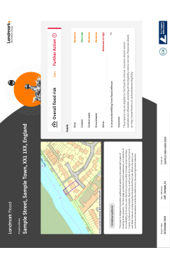
Landmark Flood is a detailed flood risk assessment. The assessment is derived following a review of a comprehensive suite of flood data extending beyond the four main sources of flooding including historic flood events, the river network and the elevation and proximity of the Site in relation to these features. If a ‘High Risk’ is indicated by flood data, an Environmental Consultant at Argyll will review the risk to ensure the overall assessment is accurate.
Includes
Flood Risk
- Assessment includes all key sources of flooding as well as proximity to and elevation above historic flood* events and watercourses. Backed by £10m PI
- Market leading assessment as data is scrutinised by an Environmental Consultant if a high risk is identified
- Sophisticated flood risk model including undefended and defended risk
- A clear report conclusion of Passed or Further Action and a ‘Professional Opinion’ to copy into the report on title.
- Insurability statement
*Data from Environment Agency and Natural resources Wales only - not available in Scotland
Assessment
Flood risk assessment that meets the needs of the Law Society’s Flood Risk Practice Notes. If high risk, an Argyll consultant will review the data.
When to use
Any residential transaction where flood risk requires proper investigation.
Please log in or register if you are interested in ordering this product.

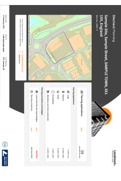
Landmark Planning provides unrivalled data accuracy through Planning Applications as Polygons, covering most of the UK.
The polygons provide a footprint for the development which is a much more accurate representation of a developments potential impact on an area. Less time is required analysing applications to understand their extent and impact.
Results of the report are clearly displayed on the easy to use, front page summary. The report looks out to varying distances based on development size so not to identify projects unnecessarily.
Landmark Planning also provides essential planning and development strategy information to homebuyers and current homeowners in mainland Great Britain. It supports the homebuyer in making an informed decision by supplying quality information for the property and surrounding area.
Includes
- Clear front-page summary identifying what applications have been identified
- Planning applications data looking within the last 7 years to inform of nearby current or future developments.
- Large Applications as Polygons for much of the UK for quicker interpretation
- Daily updates to the planning data to provide the most current view of planning across Great Britain
- Commercial and residential applications separated by development size
- Land use designations as set out in the Local Plan
Assessment
Clear front-page summary specifying what applications have been identified within the respective search radii. Supported by mapping in the report
When to use
Any residential transaction
Please log in or register if you are interested in ordering this product.
The Sitecheck Planning report provides details of what planning applications have already been submitted for approval in the area plus a view of the Local Development Plans that indicate the Local Authority’s strategic vision for future development. This provides a fuller picture of how things may change within the area.
Landmark Planning provides unrivalled data accuracy through Planning Applications as Polygons, covering most of the UK. The polygons, provide a footprint for the development which is a much more accurate representation of a developments potential impact on an area.
Includes
- Planning applications within 800m search radius
- Large Applications as Polygons for much of the UK for quicker interpretation
- Daily updates to the planning data to provide the most current view of planning across Great Britain
- Applications separated by size and end use type
- Unique interpretation of Local Development Plans and Local Development Framework (LDF), giving an insight into the local authority’s vision for future development in the area
- A link to the full application on the Local Authority website, can be found in the Data Section.
Assessment
Each project or development is checked against the site boundary. If something is found on-site or nearby, we will display "Identified" on the front page. If we don't find anything we will display "Not identified". Only issues relevant to the site will be described in this report. There will be maps and data for each individual development or project that has been identified, and based on the data that is relevant to your site, recommendations will be provided.
When to use
Any commercial transaction where development plans and applications require analysis
Please log in or register if you are interested in ordering this product.

Introducing the Landmark Climate Change Report - Helping property professionals, property investors and businesses to understand how climate change could impact a property.
It is highly important to start reporting on climate change and the numbers can prove it:
- 2022 was officially the warmest year on record for the UK (Source: BBC)
- Large-scale action in all sectors of the economy will be required, including tackling emissions generated by the building stock, which accounts for 31% of our national emissions. (Souce: Gov.uk)
- 25 percent of the UK’s total greenhouse gas emissions are attributable to the built environment. (Source: parliament.uk)
The Landmark Climate Change Report is a desktop report, designed to enable property professionals to understand how climate change could impact a given residential or commercial property.
Unlike other reports in the market, it benefits from understanding the concerns of both:
- Physical risks [flooding, subsidence, heat stress, coastal erosion]
- Transition risks [energy performance]
The report is property specific, based on a UPRN, and doesn’t stop with providing just data; delivered in an intuitive format Landmark Climate Change Report gives property professionals the ability to inform clients with advice and recommendations relating to climate change.
Who is this report for?
The Landmark Climate Change Report is for real estate lawyers and residential conveyancers¿ who want to provide best practice due diligence and inform their clients on future climate change risks
The report gives the ability to inform on short, medium and long-term physical and transitional climate-related risks for a specific property with advice and recommendations if appropriate, delivered in an intuitive format unlike current reports in the market which provide unsupported data and little explanation in every environmental report, regardless of requirements.
Further reading
Landmark asked leading experts in their property-related fields to contribute to a white paper, which sets out the physical and transitional risks that the industry faces – and proposes workable solutions to the challenge of reporting on and responding to the risks.
Read the executive summary of the Landmark Climate Change white paper here
Additional, you can also check out a series of Landmark blog posts here:
Please log in or register if you are interested in ordering this product.
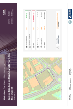
Content
The Argyll SiteSolutions Combined report is the only fully consultant led contaminated land and flood risk environmental report for commercial transactions. Every risk opinion is provided by an Environmental Consultant following a review of data and historical mapping. This approach ensures a reliable and accurate assessment of contaminated land and flood risk.
For when climate insight is required, this report also includes Landmark’s Climate risk data & assessment at no additional cost
The report also covers ground stability, radon, mining and operational compliance.
Includes
- A colour coded front-page summary with imbedded hyperlinks for fast and efficient report navigation and risk understanding
Contaminated Land
- Detailed manual review of historical maps and environmental data by an environmental consultant for every report
- Contaminated land liability assessment for Part 2A of the Environmental Protection Act backed by £10m PI
- Risk assessment for the potential presence of contamination on and off site
- Suitable for development as liability assessment includes the planning regime
- Executive summary providing top level assessment as well as fully written site analysis by the Consultant
- Recommendations flexible to the transaction
Flood Risk
- Detailed manual review of a comprehensive suite of flood risk data
- Consultants’ discussion of risk written by an environmental consultant
- Clear and concise risk assessment and summary
- Recommendation and advice tailored to significance and mechanism of risk
- Insurance availability assessment
- Undefended and defended risk assessment provided
- Assessment of what action would be required under the National Planning Policy Framework (NPPF)
Other Considerations
- Climate Change: A full assessment of physical and transitional risk showing how climate change could affect the property/site
- Ground Stability: A full assessment of ground stability including subsidence and mining to identify if a risk could risk exist
- Radon: A full assessment of whether Radon could be an issue in the location
- Operational Compliance: Confirms if an Environmental Permit is held at the Site
- COMAH: Confirm if a COMAH site is within 500m
Assessment
Manual contaminated land and flood risk assessment provided by environmental consultants that meets and exceeds the Law Society’s Contaminated Land and Flood Risk Practice Notes.
When to use
A commercial transaction when requiring either a detailed contaminated land and flood risk assessment, or if you require comprehensive environmental due diligence. Recommended: Acquisitions, Investments & Development/Change of Use.
Please log in or register if you are interested in ordering this product.

Overview
This combined product includes DevAssess Premium and Sitecheck Planning.
1. DevAssess Premium
This report offers an in-depth professional opinion on the risk of development for large residential and commercial properties. It is suitable for sites from 0.25 acres to 40 acres and includes:
- Relevant planning history of the subject property
- Identification of relevant historic planning applications 75m from the boundaries
- Planning data included at no extra cost
- Explanation of emerging and adopted Local Plan Policy
- Identification of potential future development sites where no relevant planning history exists
- Identification of land allocated for development where no relevant planning history exists
- Detailed study of the SHLAA (Strategic Housing Land Availability Assessment) sites currently being considered for future allocation
- Study of current and potential gypsy / traveller sites
- A search for changes to nearby infrastructure
- Identification of development potential of the subject property
- OS Mapping identifying potential development sites
- Aerial Photography
2. Sitecheck Planning
Sitecheck Planning provides extensive information on planning applications within 500m of the property. It also includes a development plan tracker, listing current and emerging development plans published by Local Authorities as well as the latest flooding data.
Designed for commercial sites, use this report to understand:
- What types of development are currently being carried out in the area
- Whether there are nearby planning applications that may impact the site
- How the area might change over the coming years
- What future uses of land are being proposed for nearby areas
What’s Included
- Planning Applications
- Land use designations
- Rights of way
- Housing and neighbourhood demographics
- Amenities and education
Whilst standard local authority searches are restricted to the property in question, it is crucial to investigate the surrounding area to identify changes that could have an impact on the commercial premises or site. This report will provide a summary of Planning applications in the area surrounding the site, as well as interpretation of local development plans, giving an insight into the local authority’s vision for future development in the area.
Please view sample reports for more details.
Please log in or register if you are interested in ordering this product.

The Ground Stability report from the Coal Authority combines an official CON29M with data from the British Geological Survey (BGS), highlighting specific information on the potential hazards related to natural subsidence.
This report is also available for both on and off coalfield residential property transactions.
What’s included
Each report will include any information available for the following:
- underground and opencast coal mining
- mine entries
- coal mining geology
- coal mining subsidence
- natural causes of subsidence
- mine gas and surface hazards related to coal mining
- available for both on and off coalfield transactions
Please log in or register if you are interested in ordering this product.

The Landmark commercial Chancel Report has been developed to provide an accurate analysis of any potential Chancel liabilities. If a risk is identified or further analysis of the findings is required, the PinPoint data team works in partnership with specialist University academics to provide a definitive response.
Includes
- Combines data sourced from
- Historical parishes
- National archives
- Tithe district and enclosures records
- Provided with an Accuracy Certificate backed by £3m Aviva successor in title Indemnity
Assessment
Expert interpretation and analysis from geographic historians and academics from the University of Portsmouth.
When to use
A residential transaction when you need to identify whether a property is in a parish with continuing liability
Please log in or register if you are interested in ordering this product.

The Landmark Residential Chancel Report has been developed to provide an accurate analysis of any potential Chancel liabilities. If a risk is identified or further analysis of the findings is required, the PinPoint data team works in partnership with specialist University academics to provide a definitive response.
Includes:
- Combines data sourced from
- Historical parishes
- National archives
- Tithe district and enclosures records
- Provided with an Accuracy Certificate backed by £3m Aviva successor in title Indemnity
Assessment
Expert interpretation and analysis from geographic historians and academics from the University of Portsmouth.
When to use
A residential transaction when you need to identify whether a property is in a parish with continuing liability
Please log in or register if you are interested in ordering this product.

Landmark Climate Change Report - An informative desktop report, designed to show the potential impact that climate change could have at a property when required to disclose. Landmark Climate Change report provides an overview of predicted future risk using a data baseline from UKCP18, the most authoritative UK climate projection data
Includes:
- A polygon search functionality, which allows for finer granularity and precision in reporting. Suitable for every transaction.
- Presents short, medium, and long-term climate-based risks visually through maps & graphics.
- An intuitive format providing clear explanation as well as advice and recommendations
- It includes potential changes to physical risk that may impact the property. These physical risks are listed below. The report also reviews energy performance, which is a key transitional risk for property to adapt to as the UK transitions to a low-carbon economy.
- Each section includes recommendations and advice to help the property lawyer discharge their duty when disclosing on potential future climate risks.
Physical Risks:
- Flood - Overall risk includes river, coastal and surface water flooding.
- Ground Stability - Natural subsidence risk
- Heat Stress
- Coastal Erosion
Transitional Risk: Energy Performance -
- Current Property EPC rating: Confirms if the property has an EPC, its validity, rating and when it was last inspected.
- Potential rating: Confirms what the properties potential rating, and a modelled estimate of cost to achieve rating
- Multiple EPC’s shown where relevant to the property
Other Considerations
Report introduces the topic of climate change and why it is important to help the property lawyer discharge their duty.
When to use
During a residential property transaction where the property lawyer has been instructed to disclose on potential future climate risks.
Please log in or register if you are interested in ordering this product.

The Landmark Coal residential report in collaboration with mining experts Pinpoint is a Regulated, CON29M compliant Coal Report.
The report provides property-specific information relating to past, current and future underground and surface coal mining activities, providing detailed response to all 11 key questions recommended by the Law Society Guidance Note (2018). The report includes unique analysis by Pinpoint to assess the ‘Zone of influence’ from underground workings that could have affected the property. Relevant for all mainland Great Britain.
When relevant, the report will also include a Mine Entry Interpretive Assessment and/or Subsidence Claim Interpretive Assessment.
The report includes a clear colour coded front-page action summary identify where a risk could exist. Detailed professional opinions are contained within the relevant sections of the report, in response to specific issues set out by the Law Society.
Includes:
- Assessment complaint with Law Society Guidance Note (2018)
- Underground Coal Mining (past, present or future)
- Opencast Coal Mining (past, present or future)
- Unique technical risk model that scientifically assesses the zone of influence as required by the law society CON29M.
- Mine Entries (Interpretive Mine Entry Assessment when relevant)
- Mining Geology
- Mine Gas
- Mining Subsidence Claims (Interpretive Subsidence Claim Assessment when relevant)
- Surface Hazard Call Out Incidents
- Wider BGS Recorded Mineral Mining
- Provided with an Accuracy Certificate backed by £1m Indemnity
Assessment:
Clear front-page summary as well as a detailed professional opinion when a risk has been identified in the data. Guaranteed quality assessment from industry expert at Pinpoint
When to use:
A residential transaction when a property has been identified within an area where a coal mining report, compliant with the Law Society Guidance Note (2018) should be obtained
Please log in or register if you are interested in ordering this product.

Landmarks CON29M Law Society-accredited coal report in collaboration with mining experts PinPoint, provides property-specific information relating to past, current and future underground and surface coal mining activities, for properties or sites in England, Scotland and Wales.
The report includes unique analysis by Pinpoint to assess the ‘Zone of influence’ From underground workings that could have affected the property.
Analysis is clearly presented in a simple traffic light system, with a professional opinion included as standard, providing practical next steps.
Includes
- Underground Coal Mining (past, present or future)
- Opencast Coal Mining (past, present or future)
- Unique technical risk model that scientifically assesses the zone of influence as required by the law society CON29M.
- Mine Entries
- Mining Geology
- Mine Gas
- Mining Subsidence Claims
- Surface Hazard Call Out Incidents
- Provided with an Accuracy Certificate backed by £1m Indemnity
Assessment
Clear front-page summary as well as a detailed professional opinion when a risk has been identified in the data. Guaranteed quality assessment from industry expert at Pinpoint
When to use
A residential transaction when a property has been identified within an area where a coal mining report should be obtained, and you would like an official CON29M search
Please log in or register if you are interested in ordering this product.

Landmarks Official CON29M Law Society-accredited coal report in collaboration with mining experts PinPoint, provides property-specific information relating to past, current and future underground and surface coal mining activities, for properties or sites in England, Scotland and Wales. The report includes unique analysis by Pinpoint to assess the ‘Zone of influence’ From underground workings that could have affected the property.
Answers all 11 key questions recommended by the Law Society Guidance Note (2018). Plus the 3 additional questions on working rights.
Analysis is clearly presented in a simple traffic light system, with a professional opinion included as standard, providing practical next steps.
Includes
- Underground Coal Mining (past, present or future)
- Opencast Coal Mining (past, present or future)
- Unique technical risk model that scientifically assesses the zone of influence as required by the law society CON29M.
- Mine Entries
- Mining Geology
- Mine Gas
- Mining Subsidence Claims
- Surface Hazard Call Out Incidents
- Provided with an Accuracy Certificate backed by £1m Aviva Indemnity
Assessment
Clear front-page summary as well as a detailed professional opinion when a risk has been identified in the data. Guaranteed quality assessment from industry expert at Pinpoint.
When to use
A commercial transaction when a property has been identified within an area where a coal mining report should be obtained, and you would like an official CON29M search
Please log in or register if you are interested in ordering this product.

Overview
This combined product incorporates Landmark's Homecheck Pro and Landmark Planning.
1. Homecheck Pro
Homecheck Professional provides comprehensive and easy to read reports, with information in the five key areas that are not covered by standard Local Authority searches: Enquiries of Statutory Registers, Enquiries Concerning Land Use, Enquiries Concerning Land Instability, Enquiries Concerning Natural Perils, and Enquiries Concerning Other Matters.
This report contains:
- A clear, independent assessment on contaminated land liability from Europe’s largest environmental consultancy.
- Historical Energy Facility Data, including oil and gas tanks
- Landmark’s unique Historical Land Use Data
- The latest property specific flood data
- Remediation of £60,000 when a certificate has been issued*
- Professional indemnity cover of £1 million
* subject to terms and conditions. All prices are subject to price change.
2. Landmark Planning
The Landmark Planning report will give your clients details on whether there are nearby planning applications that may impact the property as well as any types of development that are currently being carried out in the area.
Landmark Planning will uniquely display data of the majority of the UK’s large planning applications as polygons, providing a realistic understanding of the potential impact, both positive and negative, of a development.
What’s Included:
- Planning applications
- Land use designations
- Housing and neighbourhood demographics
- Amenities and education
- Rights of way
The Landmark Planning report includes the addition of useful ‘neighbourhood’ information; such as the location of telecoms masts, local footpaths, nearby schools and their performance, housing types and average prices, population demographics and local amenities. This will better inform your client, ensuring they are aware of planning decisions and socio-demographic knowledge within the surrounding area of their potential property.
View product card and sample report for full details.
Please log in or register if you are interested in ordering this product.

Overview
This combined product incorporates Landmark's Planning with the DevAssess Report by DevAssist.
1. Landmark Planning
The Landmark Planning report will give your clients details on whether there are nearby planning applications that may impact the property as well as any types of development that are currently being carried out in the area.
What’s Included:
- Planning applications
- Land use designations
- Housing and neighbourhood demographics
- Amenities and education
- Rights of way
The Landmark Planning report includes the addition of useful ‘neighbourhood’ information; such as the location of telecoms masts, local footpaths, nearby schools and their performance, housing types and average prices, population demographics and local amenities. This will better inform your client, ensuring they are aware of planning decisions and socio-demographic knowledge within the surrounding area of their potential property.
2. DevAssess
DevAssess establishes the development risk within a 75m radius from the centre of the property and identifies the new build development potential of the property. Combining existing planning information with a comprehensive investigation that exposes unexploited development sites, DevAssess reveals relevant potential development activity to homebuyers and nuisance planning applications that could affect the homebuyers enjoyment of the property. Altered views and loss of privacy can significantly reduce the value of some properties.
The report also identifies the new build development potential of the property. By exposing the hidden value, buyers could make a home an even better investment.
The report includes:
- Planning data included at no extra cost
- Identification of relevant historic planning applications within the search radius
- Explanation of Local Plan Policy
- Identification of potential future development sites where no relevant planning history exists
- Identification of land allocated for development where no relevant planning history exists
- Identification of development potential of the property
- OS Mapping identifying potential development sites
View product card and sample report for full details.
Please log in or register if you are interested in ordering this product.
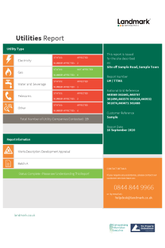
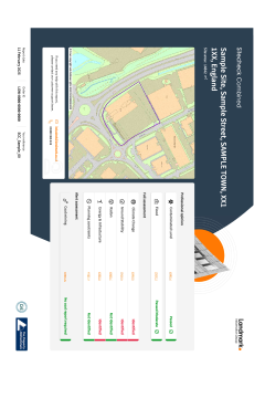
Overview
Knowledge of features below the surface is essential for every development. Designed for commercial sites and redevelopments, the Utilities Report provides a very comprehensive search for underground service information relevant to your development site, including gas and oil pipelines, electricity cables, telecommunication wires, mains water supplies, sewerage and fibre-optic cables.
With a clear front page summary showing report status and affected utility types, this report includes:
- Comprehensive search of 35-45 utilities for each site
- Status report confirming utility service responses
- Effective report separated into affected and unaffected responses
- Robust quality assurance with every plan checked for accuracy
- Up-to-date information guaranteed with a new search on every site
Landmark's Utilities report prevents time consuming correspondence with a number of utilities companies, and reduce the risk of expensive litigation and danger for the workforce involved.
Responses are separated into ‘Affected’ and ‘Unaffected’ sections, to ensure all important information is quickly apparent. Utility company response plans are provided for all affected responses, and all not affected responses evidenced for your records.
Professional Indemnity
Cover of £10million, subject to terms and conditions.
Turnaround times
Please note this Utilities Report is the Express Service, with a turnaround of 5 working days. For other options please select the following:
- Standard Service (20 working days)
- Premium Service (10 working days)

Overview Plan
There is now an add-on feature, the Overview Plan, which allows you to quickly and easily navigate all affected utility information on a single summary map. This is only available with the Standard Service (20 working days). Click here to order this product.
View our product card and sample report for full details.
Please log in or register if you are interested in ordering this product.

Overview
Knowledge of features below the surface is essential for every development. Designed for commercial sites and redevelopments, the Utilities Report provides a very comprehensive search for underground service information relevant to your development site, including gas and oil pipelines, electricity cables, telecommunication wires, mains water supplies, sewerage and fibre-optic cables.
With a clear front page summary showing report status and affected utility types, this report includes:
- Comprehensive search of 35-45 utilities for each site
- Status report confirming utility service responses
- Effective report separated into affected and unaffected responses
- Robust quality assurance with every plan checked for accuracy
- Up-to-date information guaranteed with a new search on every site
Landmark's Utilities report prevents time consuming correspondence with a number of utilities companies, and reduce the risk of expensive litigation and danger for the workforce involved.
Responses are separated into ‘Affected’ and ‘Unaffected’ sections, to ensure all important information is quickly apparent. Utility company response plans are provided for all affected responses, and all not affected responses evidenced for your records.
Professional Indemnity
Cover of £10million, subject to terms and conditions.
Turnaround times
Please note this Utilities Report is the Premium Service, with a turnaround of 10 working days. For other options please select the following:
- Standard Service (20 working days)
- Express Service (5 working days)
Overview Plan
There is now an add-on feature, the Overview Plan, which allows you to quickly and easily navigate all affected utility information on a single summary map. This is only available with the Standard Service (20 working days). Click here to order this product.
View our product card and sample report for full details.
Please log in or register if you are interested in ordering this product.

Overview
Knowledge of features below the surface is essential for every development. Designed for commercial sites and redevelopments, the Utilities Report provides a very comprehensive search for underground service information relevant to your development site, including gas and oil pipelines, electricity cables, telecommunication wires, mains water supplies, sewerage and fibre-optic cables.
With a clear front page summary showing report status and affected utility types, this report includes:
- Comprehensive search of 35-45 utilities for each site
- Status report confirming utility service responses
- Effective report separated into affected and unaffected responses
- Robust quality assurance with every plan checked for accuracy
- Up-to-date information guaranteed with a new search on every site
Landmark's Utilities report prevents time consuming correspondence with a number of utilities companies, and reduce the risk of expensive litigation and danger for the workforce involved.
Responses are separated into ‘Affected’ and ‘Unaffected’ sections, to ensure all important information is quickly apparent. Utility company response plans are provided for all affected responses, and all not affected responses evidenced for your records.
Professional Indemnity
Cover of £10million, subject to terms and conditions.
Turnaround times
Please note this Utilities Report is the Standard Service, with a turnaround of 20 working days. For other options please select the following:
- Express Service (5 working days)
- Premium Service (10 working days)
Overview Plan
There is now an add-on feature, the Overview Plan, which allows you to quickly and easily navigate all affected utility information on a single summary map. This is only available with the Standard Service (20 working days). Click here to order this product.
View our product card and sample report for full details.
Please log in or register if you are interested in ordering this product.
The Sitecheck Combined provides both a contaminated land liability risk assessment under Part 2A of the Environmental Protection Act (1990) as well as a flood risk assessment, which is reviewed by an Argyll Consultant if a high risk is identified. As it is all encompassing, it also provides a full review of climate change, ground stability, , radon, energy and infrastructure projects and planning constraints. It also includes an alert assessment to determine if coal mining could affect the property.
Includes
Professional Opinion
- Contaminated land liability assessment with ‘Professional Opinion’ for Part 2A of the EPA. Providing a clear report conclusion of Passed or Further Action to copy into the report on title. Includes Landmark’s innovative and ever expanding ‘Risk Assessed Land Register’ dataset to provide more passes early on
- Flood Risk - A clear report conclusion of Passed, Passed Moderate or Further Action with a ‘Professional Opinion’ to copy into the report on title. Assessment includes all key sources of flooding, flood defences as well as proximity to and elevation above historic flood events and watercourses. The result is scrutinised by an Environmental Consultant if a high risk is identified
Full Assessment:
- Climate change: a comprehensive assessment of key data sets to understand future risk from both physical & transition risk.
- Ground Stability: A detailed ground stability, subsidence and mining assessment to identify if a risk could exist.
- Radon: An assessment of whether Radon could be an issue in the location
- Energy & Infrastructure: A detailed review of a wide variety of energy or transport projects. Search radius up to 4km search radius
- Planning constraints are highlighted
Alert Assessment:
- Coal risk - A market-first, ‘No search’ certificate. Alongside and integral to the Coal Screening Data Layer is Landmark’s certification as to the result’s accuracy, where ‘No’ or ‘Low’ risk is identified. Landmark’s certification is backed by a £1M indemnity policy.
When to use
Use for commercial property transaction including purchase & leases. Where there is planned development or change of use, we recommend using SiteSolutions commercial or combined.
Please log in or register if you are interested in ordering this product.