

Landmark Sitecheck Planning
Supplied by: Landmark
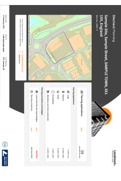
The Sitecheck Planning report provides details of what planning applications have already been submitted for approval in the area plus a view of the Local Development Plans that indicate the Local Authority’s strategic vision for future development. This provides a fuller picture of how things may change within the area.
Landmark Planning provides unrivalled data accuracy through Planning Applications as Polygons, covering most of the UK. The polygons, provide a footprint for the development which is a much more accurate representation of a developments potential impact on an area.
Includes
- Planning applications within 800m search radius
- Large Applications as Polygons for much of the UK for quicker interpretation
- Daily updates to the planning data to provide the most current view of planning across Great Britain
- Applications separated by size and end use type
- Unique interpretation of Local Development Plans and Local Development Framework (LDF), giving an insight into the local authority’s vision for future development in the area
- A link to the full application on the Local Authority website, can be found in the Data Section.
Assessment
Each project or development is checked against the site boundary. If something is found on-site or nearby, we will display "Identified" on the front page. If we don't find anything we will display "Not identified". Only issues relevant to the site will be described in this report. There will be maps and data for each individual development or project that has been identified, and based on the data that is relevant to your site, recommendations will be provided.
When to use
Any commercial transaction where development plans and applications require analysis
Please log in or register if you are interested in ordering this product.
Popular Products
CON29DW Geodesys (Anglian Water)
This official CON29DW, available from OneSearch Direct, provides comprehensive data on water supply, sewer connection status and charging arrangements.
Groundsure Avista
An environmental property search report powered by Groundsure that includes seven key searches: Contaminated land, flood risk, ground stability, other environmental risks such as radon, energy searches including fracking, transportation and planning.