

Landmark Envirosearch Residential and Landmark Planning
Supplied by: Landmark
Overview
This combined product incorporates Landmark's Envirosearch Residential and Plansearch Plus.
1. Envirosearch Residential
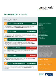
Envirosearch Residential provides a comprehensive review of potential environmental risks affecting a property, including contaminated land, flood, ground stability, and radon. Meeting the needs of Part 2A of the Environmental Protection Act 1990, the report also includes other factors such as HS2, fracking, solar and windfarms; ensuring appropriate due diligence for every transaction.
This report contains:
- Complete historical mapping information on: Standard Environmental Enquiries, Past and Current Industrial Land Use, Mining, Radon and Ground Stability.
- The latest flood data including the identification of flood defences as recorded by the Environment Agency. Includes surface water (pluvial) flooding.
- Overhead powerlines included
- The report includes independent, professional opinion by leading chartered surveyors, Wilbourn Associates.
- Remediation contribution of up to £60,000, regardless of report result*
- PI Cover
* subject to terms and conditions. All prices are subject to price change.
Expert professional opinion included
Every Envirosearch report comes with recommendations and a professional opinion from Argyll Environmental, Landmark's experts in specialist risk management services - providing clear and positive guidance, which can be copied into client reports.
Simple to read
Designed so your clients can digest and understand the guidance and next steps with ease, Envirosearch Residential will save you time dealing with related questions.
2. Landmark Planning
The Landmark Planning report will give your clients details on whether there are nearby planning applications that may impact the property as well as any types of development that are currently being carried out in the area.
Landmark Planning will uniquely display data of the majority of the UK’s large planning applications as polygons, providing a realistic understanding of the potential impact, both positive and negative, of a development.
What’s Included:
- Planning applications
- Land use designations
- Housing and neighbourhood demographics
- Amenities and education
- Rights of way
The Landmark Planning report includes the addition of useful ‘neighbourhood’ information; such as the location of telecoms masts, local footpaths, nearby schools and their performance, housing types and average prices, population demographics and local amenities. This will better inform your client, ensuring they are aware of planning decisions and socio-demographic knowledge within the surrounding area of their potential property.
View product card and sample report for full details.
Please log in or register if you are interested in ordering this product.
Popular Products

Severn Trent CON29DW Commercial Extra
CON29DW Severn Trent - Commercial Severn Trent Water
confirmly
Confirmly by LMS