Groundsure products
Groundsure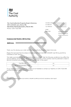
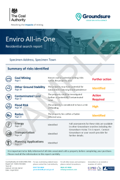
The enhanced Enviro All-in-One, is a fully integrated residential environmental risk report. It is the only available report to combine the official CON29M coal mining search with flood, contaminated land, ground stability and radon searches. It also screens other environmental risks such as energy installations, transportation and planning applications.
Please log in or register if you are interested in ordering this product.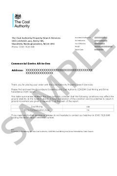

Overview
Historic mining and ground stability affects properties across the country - your clients’ transactions need protecting.
A full mining solution for the conveyancing process - the only desktop mining report you will ever need. Groundsure GeoRisk is not just data – the report’s value rests on advanced data analysis delivering expert insight, interpretation and an extensive understanding of natural and man-made ground risks to property.
- GeoRisk provides a detailed assessment of mining and ground risk backed up by in depth and vast datasets covering five key areas: Non-coal mining (with opinion provided by an in-house mining expert)
- Ground stability (non-mining, both natural and non-natural)
- Satellite monitoring (recorded ‘real-world’ ground movement brought to you by SatSense)
- Coal mining (GeoRisk +)*
- Brine* (GeoRisk +)* *GeoRisk + includes everything in the GeoRisk report plus a fully comprehensive Groundsure CON29M Official Coal Mining Search Report (including a mine entry interpretive assessment) and a Cheshire Salt Search where required.
What is in GeoRisk
MSUK Mining Features: Unique and authoritative data on past mining features and associated infrastructure derived from mine plans and other sources, collated and curated by MSUK across 40 years of consulting.
Mining Records: Rich data indicating the presence or likelihood of past mining activity from a variety of authoritative sources.
Historical features: Past mining activity as depicted on historical maps. Mining features from Groundsure’s unique and comprehensive Historical Land Use Database derived from analysis of 1.5 million high resolution scans of historical OS maps.
Geological features: Geological data from the British Geological Survey (BGS) that could indicate the presence of past mining activity. This data is provided at the highest resolution available (1:10,000 scale).
Oil and gas extraction: Data on the presence or potential presence of oil and gas extraction. Information on exploration areas (‘licensed’ and ‘offered’), alongside existing wells and, unique to Groundsure, potential wells identified in the planning system - giving advanced warning of future development.
Satellite monitoring: Satellite radar data analysed to measure real-world ground movement, accurate to the millimetre. Produced by ground movement experts SatSense and updated every six days on a continuous cycle. Risk to property is summarised into a simple traffic light system across six risk indices, relating to different spatial scales and types of movement.
Natural instability: Comprehensive natural instability data including brand new BGS data on the risk from shrink-swell subsidence. It looks at geology, the presence of trees (Bluesky’s National Tree Map), and local building attributes to deliver a clear hazard score. Full GeoSure data is also included, natural cavities data and the BGS National Landslides Index.
Infilled land: Areas of infilled land can often indicate ground instability. Data is provided on current and historical landfills, along with unique and proprietary data derived from historical mapping and local authority records.
Sinkholes: A comprehensive alert to the likely presence of sinkholes. Includes recent sinkhole incidents in media reports, incidents recorded by the BGS and PBA, and past incidents from Groundsure’s Historical Land Use Database.
Coastal erosion: Understand risks to property from loss of land to the sea. Projections on imminent risk are provided alongside potential risk to your clients’ long term property investment
Coal mining alert: Alerts to a need for a full coal mining risk assessment if the property is within the Coal Mining Reporting Area.
Cheshire brine alert: Alerts to a need for a full brine risk assessment if the property is within the Cheshire Brine Compensation District.
GeoRisk gives the expert, bespoke view needed for property and land transactions, with a clean design and user friendly easy to navigate layout. GeoRisk has been designed and enhanced with comprehensive data features, clean and easy to read layout and design for clearer navigation - streamlining workflow. Where the comprehensive GeoRisk Alerts give the all-clear for specific or combinations of risks, deliver peace of mind to your customers with the new and cost-effective and competitively priced GeoRisk Certificate products.
Please view product card and sample report for more details.
Please log in or register if you are interested in ordering this product.

Overview
Historic mining and ground stability affects properties across the country - your clients’ transactions need protecting.
A full mining solution for the conveyancing process - the only desktop mining report you will ever need. Groundsure GeoRisk is not just data – the report’s value rests on advanced data analysis delivering expert insight, interpretation and an extensive understanding of natural and man-made ground risks to property.
- GeoRisk provides a detailed assessment of mining and ground risk backed up by in depth and vast datasets covering five key areas: Non-coal mining (with opinion provided by an in-house mining expert)
- Ground stability (non-mining, both natural and non-natural)
- Satellite monitoring (recorded ‘real-world’ ground movement brought to you by SatSense)
- Coal mining (GeoRisk +)*
- Brine* (GeoRisk +)* *GeoRisk + includes everything in the GeoRisk report plus a fully comprehensive Groundsure CON29M Official Coal Mining Search Report (including a mine entry interpretive assessment) and a Cheshire Salt Search where required.
What is in GeoRisk
MSUK Mining Features: Unique and authoritative data on past mining features and associated infrastructure derived from mine plans and other sources, collated and curated by MSUK across 40 years of consulting.
Mining Records: Rich data indicating the presence or likelihood of past mining activity from a variety of authoritative sources.
Historical features: Past mining activity as depicted on historical maps. Mining features from Groundsure’s unique and comprehensive Historical Land Use Database derived from analysis of 1.5 million high resolution scans of historical OS maps.
Geological features: Geological data from the British Geological Survey (BGS) that could indicate the presence of past mining activity. This data is provided at the highest resolution available (1:10,000 scale).
Oil and gas extraction: Data on the presence or potential presence of oil and gas extraction. Information on exploration areas (‘licensed’ and ‘offered’), alongside existing wells and, unique to Groundsure, potential wells identified in the planning system - giving advanced warning of future development.
Satellite monitoring: Satellite radar data analysed to measure real-world ground movement, accurate to the millimetre. Produced by ground movement experts SatSense and updated every six days on a continuous cycle. Risk to property is summarised into a simple traffic light system across six risk indices, relating to different spatial scales and types of movement.
Natural instability: Comprehensive natural instability data including brand new BGS data on the risk from shrink-swell subsidence. It looks at geology, the presence of trees (Bluesky’s National Tree Map), and local building attributes to deliver a clear hazard score. Full GeoSure data is also included, natural cavities data and the BGS National Landslides Index.
Infilled land: Areas of infilled land can often indicate ground instability. Data is provided on current and historical landfills, along with unique and proprietary data derived from historical mapping and local authority records.
Sinkholes: A comprehensive alert to the likely presence of sinkholes. Includes recent sinkhole incidents in media reports, incidents recorded by the BGS and PBA, and past incidents from Groundsure’s Historical Land Use Database.
Coastal erosion: Understand risks to property from loss of land to the sea. Projections on imminent risk are provided alongside potential risk to your clients’ long term property investment
Coal mining alert: Alerts to a need for a full coal mining risk assessment if the property is within the Coal Mining Reporting Area.
Cheshire brine alert: Alerts to a need for a full brine risk assessment if the property is within the Cheshire Brine Compensation District.
What is in GeoRisk +
GeoRisk + includes everything in the GeoRisk report plus a fully comprehensive Groundsure CON29M Official Coal Mining Search Report (including a mine entry interpretive assessment) and a Cheshire Salt Search where required.
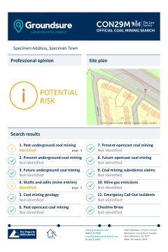
Coal mining (CON29M): A full assessment of the potential risk from coal mining with a CON29M Official Coal Mining Search integrated into the report and risk assessment. Also includes a mine entry interpretive assessment as standard. Residential and commercial versions available where applicable.
Cheshire brine: A full Cheshire Salt Search is included with the report when the property is within the Cheshire Brine Compensation District and includes further information on records held by the Cheshire Brine Subsidence Compensation Board.
GeoRisk gives the expert, bespoke view needed for property and land transactions, with a clean design and user friendly easy to navigate layout. GeoRisk has been designed and enhanced with comprehensive data features, clean and easy to read layout and design for clearer navigation - streamlining workflow. Where the comprehensive GeoRisk Alerts give the all-clear for specific or combinations of risks, deliver peace of mind to your customers with the new and cost-effective and competitively priced GeoRisk Certificate products.
Please view product card and sample report for more details.
Please log in or register if you are interested in ordering this product.

Overview
Historic mining and ground stability affects properties across the country - your clients’ transactions need protecting.
A full mining solution for the conveyancing process - the only desktop mining report you will ever need. Groundsure GeoRisk is not just data – the report’s value rests on advanced data analysis delivering expert insight, interpretation and an extensive understanding of natural and man-made ground risks to property.
- GeoRisk provides a detailed assessment of mining and ground risk backed up by in depth and vast datasets covering five key areas: Non-coal mining (with opinion provided by an in-house mining expert)
- Ground stability (non-mining, both natural and non-natural)
- Satellite monitoring (recorded ‘real-world’ ground movement brought to you by SatSense)
- Coal mining (GeoRisk +)*
- Brine* (GeoRisk +)* *GeoRisk + includes everything in the GeoRisk report plus a fully comprehensive Groundsure CON29M Official Coal Mining Search Report (including a mine entry interpretive assessment) and a Cheshire Salt Search where required.
What is in GeoRisk
MSUK Mining Features: Unique and authoritative data on past mining features and associated infrastructure derived from mine plans and other sources, collated and curated by MSUK across 40 years of consulting.
Mining Records: Rich data indicating the presence or likelihood of past mining activity from a variety of authoritative sources.
Historical features: Past mining activity as depicted on historical maps. Mining features from Groundsure’s unique and comprehensive Historical Land Use Database derived from analysis of 1.5 million high resolution scans of historical OS maps.
Geological features: Geological data from the British Geological Survey (BGS) that could indicate the presence of past mining activity. This data is provided at the highest resolution available (1:10,000 scale).
Oil and gas extraction: Data on the presence or potential presence of oil and gas extraction. Information on exploration areas (‘licensed’ and ‘offered’), alongside existing wells and, unique to Groundsure, potential wells identified in the planning system - giving advanced warning of future development.
Satellite monitoring: Satellite radar data analysed to measure real-world ground movement, accurate to the millimetre. Produced by ground movement experts SatSense and updated every six days on a continuous cycle. Risk to property is summarised into a simple traffic light system across six risk indices, relating to different spatial scales and types of movement.
Natural instability: Comprehensive natural instability data including brand new BGS data on the risk from shrink-swell subsidence. It looks at geology, the presence of trees (Bluesky’s National Tree Map), and local building attributes to deliver a clear hazard score. Full GeoSure data is also included, natural cavities data and the BGS National Landslides Index.
Infilled land: Areas of infilled land can often indicate ground instability. Data is provided on current and historical landfills, along with unique and proprietary data derived from historical mapping and local authority records.
Sinkholes: A comprehensive alert to the likely presence of sinkholes. Includes recent sinkhole incidents in media reports, incidents recorded by the BGS and PBA, and past incidents from Groundsure’s Historical Land Use Database.
Coastal erosion: Understand risks to property from loss of land to the sea. Projections on imminent risk are provided alongside potential risk to your clients’ long term property investment
Coal mining alert: Alerts to a need for a full coal mining risk assessment if the property is within the Coal Mining Reporting Area.
Cheshire brine alert: Alerts to a need for a full brine risk assessment if the property is within the Cheshire Brine Compensation District.
What is in GeoRisk +
GeoRisk + includes everything in the GeoRisk report plus a fully comprehensive Groundsure CON29M Official Coal Mining Search Report (including a mine entry interpretive assessment) and a Cheshire Salt Search where required.
Coal mining (CON29M): A full assessment of the potential risk from coal mining with a CON29M Official Coal Mining Search integrated into the report and risk assessment. Also includes a mine entry interpretive assessment as standard. Residential and commercial versions available where applicable.
Cheshire brine: A full Cheshire Salt Search is included with the report when the property is within the Cheshire Brine Compensation District and includes further information on records held by the Cheshire Brine Subsidence Compensation Board.
GeoRisk gives the expert, bespoke view needed for property and land transactions, with a clean design and user friendly easy to navigate layout. GeoRisk has been designed and enhanced with comprehensive data features, clean and easy to read layout and design for clearer navigation - streamlining workflow. Where the comprehensive GeoRisk Alerts give the all-clear for specific or combinations of risks, deliver peace of mind to your customers with the new and cost-effective and competitively priced GeoRisk Certificate products.
Please view product card and sample report for more details.
Please log in or register if you are interested in ordering this product.

Overview
Historic mining and ground stability affects properties across the country - your clients’ transactions need protecting.
A full mining solution for the conveyancing process - the only desktop mining report you will ever need. Groundsure GeoRisk is not just data – the report’s value rests on advanced data analysis delivering expert insight, interpretation and an extensive understanding of natural and man-made ground risks to property.
- GeoRisk provides a detailed assessment of mining and ground risk backed up by in depth and vast datasets covering five key areas: Non-coal mining (with opinion provided by an in-house mining expert)
- Ground stability (non-mining, both natural and non-natural)
- Satellite monitoring (recorded ‘real-world’ ground movement brought to you by SatSense)
- Coal mining (GeoRisk +)*
- Brine* (GeoRisk +)* *GeoRisk + includes everything in the GeoRisk report plus a fully comprehensive Groundsure CON29M Official Coal Mining Search Report (including a mine entry interpretive assessment) and a Cheshire Salt Search where required.
What is in GeoRisk
MSUK Mining Features: Unique and authoritative data on past mining features and associated infrastructure derived from mine plans and other sources, collated and curated by MSUK across 40 years of consulting.
Mining Records: Rich data indicating the presence or likelihood of past mining activity from a variety of authoritative sources.
Historical features: Past mining activity as depicted on historical maps. Mining features from Groundsure’s unique and comprehensive Historical Land Use Database derived from analysis of 1.5 million high resolution scans of historical OS maps.
Geological features: Geological data from the British Geological Survey (BGS) that could indicate the presence of past mining activity. This data is provided at the highest resolution available (1:10,000 scale).
Oil and gas extraction: Data on the presence or potential presence of oil and gas extraction. Information on exploration areas (‘licensed’ and ‘offered’), alongside existing wells and, unique to Groundsure, potential wells identified in the planning system - giving advanced warning of future development.
Satellite monitoring: Satellite radar data analysed to measure real-world ground movement, accurate to the millimetre. Produced by ground movement experts SatSense and updated every six days on a continuous cycle. Risk to property is summarised into a simple traffic light system across six risk indices, relating to different spatial scales and types of movement.
Natural instability: Comprehensive natural instability data including brand new BGS data on the risk from shrink-swell subsidence. It looks at geology, the presence of trees (Bluesky’s National Tree Map), and local building attributes to deliver a clear hazard score. Full GeoSure data is also included, natural cavities data and the BGS National Landslides Index.
Infilled land: Areas of infilled land can often indicate ground instability. Data is provided on current and historical landfills, along with unique and proprietary data derived from historical mapping and local authority records.
Sinkholes: A comprehensive alert to the likely presence of sinkholes. Includes recent sinkhole incidents in media reports, incidents recorded by the BGS and PBA, and past incidents from Groundsure’s Historical Land Use Database.
Coastal erosion: Understand risks to property from loss of land to the sea. Projections on imminent risk are provided alongside potential risk to your clients’ long term property investment
Coal mining alert: Alerts to a need for a full coal mining risk assessment if the property is within the Coal Mining Reporting Area.
Cheshire brine alert: Alerts to a need for a full brine risk assessment if the property is within the Cheshire Brine Compensation District.
GeoRisk gives the expert, bespoke view needed for property and land transactions, with a clean design and user friendly easy to navigate layout. GeoRisk has been designed and enhanced with comprehensive data features, clean and easy to read layout and design for clearer navigation - streamlining workflow. Where the comprehensive GeoRisk Alerts give the all-clear for specific or combinations of risks, deliver peace of mind to your customers with the new and cost-effective and competitively priced GeoRisk Certificate products.
Please view product card and sample report for more details.
Please log in or register if you are interested in ordering this product.

Overview
This combined product incorporates Groundsure Planning with the DevAssess Report by DevAssist.
1. Groundsure Planning
Groundsure utilises the most accurate and complete planning history data from its sister Emap company, Glenigan, to provide GroundSure Planning. Providing detailed planning application information within the vicinity of the property, dating back 10 years, it features full planning information ranging from house extensions through to large planning project applications as well as existing and planned phone masts.
What does it cover?
- House extension and project planning applications from the last 10 years
- Ofcom mobile phone mast locations & planning applications relating to phone masts
- Designated environmentally sensitive sites
- Local information including transport, recreation, retail and entertainment
- Local Authority data including Council Tax bands and police force
- Education data inspection ratings
- Crime statistics by crime type
Groundsure Planning utilises the most accurate and complete commercially available historical and current planning data, and is recognised as the most comprehensive data of its kind.
2. DevAssess
DevAssess establishes the development risk within a 75m radius from the centre of the property and identifies the new build development potential of the property. Combining existing planning information with a comprehensive investigation that exposes unexploited development sites, DevAssess reveals relevant potential development activity to homebuyers and nuisance planning applications that could affect the homebuyers enjoyment of the property. Altered views and loss of privacy can significantly reduce the value of some properties.
The report also identifies the new build development potential of the property. By exposing the hidden value, buyers could make a home an even better investment.
The report includes:
- Planning data included at no extra cost
- Identification of relevant historic planning applications within the search radius
- Explanation of Local Plan Policy
- Identification of potential future development sites where no relevant planning history exists
- Identification of land allocated for development where no relevant planning history exists
- Identification of development potential of the property
- OS Mapping identifying potential development sites
View product card and sample report for full details.
Please log in or register if you are interested in ordering this product.

Overview
Groundsure Agricultural provides a full assessment on banking security. It covers past and present land use of the farming site and comes with expert interpretation and opinion from Groundsure’s IEMA qualified consultants. Includes topography data, land use classifications and stewardship schemes. It also accesses Groundsure’s unique historical data which has specific land use records dating back to the 1840s.
**NEW FEATURES** Following an extensive research programme with Property Lawyers and PSLs from leading law firms across the UK, Groundsure’s Agricultural Search has been redeveloped with new data, features, improved layout and a new design. The outcome – a streamlined workflow getting the information that your clients need faster, via a much more user-friendly design and navigation.
What does it cover?
The report now provides enhanced guidance on Section B8 of the Law Society Conveyancing Handbook (25th ed.) with information including:
- Multi-tier environmental risk assessment
- In-depth contaminated land database dating back to 1840s including 27,000+ land use classifications
- Environmental permits, incidents and registers
- Detailed active and historical landfill data from authoritative sources, including the Environment Agency, Natural Resources Wales, British Geological Survey (BGS), Local Authorities and historical Ordnance Survey mapping
- National Grid gas pipeline and electricity transmission lines
- Hydrology and Hydrogeology
- NEW Historic and Current Rights of Way (CRoW) - Open Access Land
- High Speed 2 (HS2) rail network – proximity to potential build disruption and purchase risks
- Detailed commentary on working farmyards
- NEW Agricultural Land Classification, indicating the land’s potential productivity
- Subsidence hazards from mining and natural sources
- Designated Environmentally Sensitive Sites including ancient or protected woodland.
- Assessment of archaeological sites of interest.
- NEW Timber felling licenses
- NEW Waste exemptions
- NEW Environmental and Countryside Stewardship Schemes
- Discharge consents
- Nitrate Vulnerable Zones
Reliance
£10m Professional Indemnity Insurance (any one claim). Can be relied upon by all professional parties within a property transaction, first purchasers / tenants and their advisers. Please refer to Groundsure terms & conditions.
Inform your clients of any environmental risks that may affect their farm purchase with Groundsure's tailored agricultural conveyancing search.
Please log in or register if you are interested in ordering this product.
- Law Society compliant/regulated – answers all 11 and 14 questions for residential and commercial
- Comes with a £100,000 insurance policy from Zurich
- In conjunction with well-known and trusted industry experts Mining Searches UK
- Comes with a property specific Brine alert
Please log in or register if you are interested in ordering this product.

Groundsure is proud to be the sole provider of the Cheshire Salt Search report. It is a Law Society requirement to investigate subsidence risk due to brine extraction in Cheshire. Much of Cheshire is at increased risk of subsidence due to mining practices. In addition previous compensation payouts mean that some properties are not eligible for relevant compensation. The report provides invaluable information for consideration before a property in Cheshire is purchased or developed. This data was previously part of the Coal Authority's CON29M report but is now a new standalone report that can be bought alongside the new Enviro All-in-One or other Groundsure searches when required.
Please log in or register if you are interested in ordering this product.

Groundsure’s Energy and Transportation is a new report providing a comprehensive search of existing and planned energy and transport infrastructure. Including data unique to Groundsure, the report uses our unique intelligent filtering to provide only relevant information, and provides clear next steps for your transaction.
What does it cover?
-
Existing or proposed oil, gas, coalbed methane and shale gas sites. Proposed sites updated weekly. Also identifies if the property is within either a Licensed Block or a block that has been offered for future exploration
-
Existing or proposed large scale energy infrastructure projects (incl. the Yorkshire & Humber CCS Pipeline, the Keuper Gas Storage Project, the Richborough Connection Project and 95 other projects)
-
Existing large scale transmission networks
-
Existing or proposed power stations
including nuclear facilities
-
Existing or proposed wind turbines, wind farms and solar farms. Where proposed sites are identified, full planning application details are provided for further investigation.
-
HS2 data includes the route and
-
stations but also safeguarding areas, compensation schemes and “never seen before” noise and visual impact assessment data. Gives the nearest point both over and below ground, and identifies the track grade and maximum speed of the train at the nearest point.
-
Crossrail 1 and 2 route, overall construction timetable and station location. Also includes any designated safeguarding areas.
-
Underground railways. Full route
and operational times are included
for the London Underground and Docklands Light Railway alongside
our proprietary modelled depth data. Stations and proposed tube extensions are included. Full route information is included for the Tyne and Wear Metro, Merseyrail and Glasgow Subway. -
Active and historical railways and tunnels digitised by Groundsure from the highest quality historical mapping available. Also includes location of nearby railway stations
Reliance - £10m Professional Indemnity Insurance (any one claim). Can be relied upon by all professional parties within a property transaction, first purchasers / tenants and their advisers. Please refer to Groundsure terms and conditions.
Please log in or register if you are interested in ordering this product.
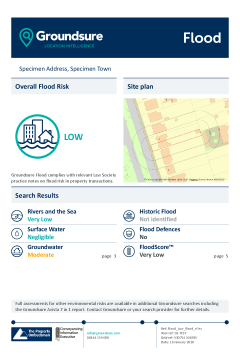
Overview
According to the Environment Agency, over 5 million people in England and Wales live and work in properties that are at risk of flooding.
It is not only tidal and river flooding that needs to be considered. More often it can be groundwater and pluvial (surface water) that cause, or contribute, to the issue. This report provides a detailed assessment of flood risk, and the impacts flooding could have on your client’s property.
What does it cover?
- River and Coastal flood risk data from the Environment Agency including RoFRaS, Flood Defences and Proposed Flood Defence Schemes
- Surface water (pluvial) flood risk data from JBA Risk Management
- Groundwater flooding susceptibility data from the British Geological Survey
- Recorded Historic Flood Events
- Flood risk insurability likelihood provided by JBA Risk Management
The report includes unique Groundsure risk analysis as well as a view on flood risk insurability and offers access to IEMA qualified environmental consultants for further advice and support.
Please log in or register if you are interested in ordering this product.
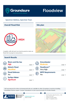
Overview
Groundsure Floodview is a comprehensive flood risk search for commercial properties, consisting of a fully interpreted flood risk assessment and a view on the likely availability of flood risk insurance for the property. The report utilises Groundsure’s detailed flood risk databases which includes detail from JBA Risk Management, the Environment Agency and the British Geological Survey.
What does it cover?
- River and Coastal flood risk data from the Environment Agency or Natural Resources Wales, including Flood Zones, RoFRaS, Flood Defences and Proposed Flood Defence Schemes
- Surface water (pluvial) flood risk data from JBA Risk Management
- Groundwater flooding susceptibility data from the British Geological Survey
- Recorded Historic Flood Events
- JBA Risk Management Reservoir Failure
- Geological indicators of historical flooding
- Likelihood of flood risk insurance availability
For total clarity, the Groundsure Floodview indicates different flood hazards on separate maps; for increased peace of mind, if a site is identified as high risk, Groundsure can connect you with environmental insurance solutions and IEMA qualified environmental consultants are on hand to provide guidance and support.
Please log in or register if you are interested in ordering this product.
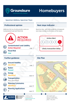
Overview
Homebuyers provides comprehensive environmental checks for a residential property aiding your due diligence and providing peace of mind to your clients. This search report has just been given a substantial makeover. These product improvements are a result of in depth market research via qualitative and quantitative surveys, focus groups and research panels. Every change was assessed and approved by a panel of conveyancers to ensure that the changes are right for you. Homebuyers still includes everything you were used to seeing but, new from the 1st July, the report will also include:
- A unique Action Alert case management tool
- Full planning search (inc. planning polygons**)
- Full energy search
- Full transportation search
Seven key risks assessed in a single search report
- Contaminated land liability
- Flood risk
- Ground stability
- Radon
- Transportation
- Energy
- Planning applications/constraints
The Homebuyers now includes an enhanced energy alert detailing specific energy infrastructure categories within 5km of the property. This alert includes existing and proposed: oil and gas sites including fracking; power stations including nuclear; wind power projects; solar farms and major energy infrastructure projects.
This report also full planning with development extents, energy and transportation searches, and a new Action Alert - as standard.
Homebuyers is used by solicitors, and is accepted by all major UK lenders to ensure maximum due diligence for residential property purchases.
Please view sample report and product card for full details.
Please log in or register if you are interested in ordering this product.

Overview
Contains the same high quality environmental information and expert opinion as the GroundSure Homebuyers report, with a primary difference being that the report includes a “screen” against the potential risk of flooding. This screen may identify the requirement for a further food risk report to be required.
What does it cover?
- Contaminated land assessment based on Groundsure’s unique historical land use database
- Potentially in-filled land
- Up-to-date environmental permit, incidents and registers data
- Historical and active landfill sites
- Ground stability assessment including non-coal mining, cavities and subsidence risks
- Coal mining screening JBA Risk Management river, coastal and surface water flood screen
- Energy alert highlighting existing or planned energy installations, such as wind turbines or fracking
- Unique “London Rail Networks” alert identifying the presence of the London Underground, DLR, active railways and abandoned railways and tunnels
Groundsure Homescreen enables solicitors to comply with the requirements of the Law Society Practice Note on Contaminated Land and considers the risk of the property being designated under Part 2A of the Environmental Protection Act 1990, together with other key natural and man-made hazards.
Please log in or register if you are interested in ordering this product.

Please log in or register if you are interested in ordering this product.
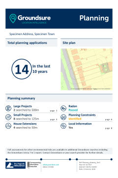
Overview
Groundsure utilises the most accurate and complete planning history data from its sister Emap company, Glenigan, to provide GroundSure Planning. Providing detailed planning application information within the vicinity of the property, dating back 10 years, it features full planning information ranging from house extensions through to large planning project applications as well as existing and planned phone masts.
What does it cover?
-
House extension and project planning applications from the last 10 years
-
Ofcom mobile phone mast locations & planning applications relating to phone masts
-
Designated environmentally sensitive sites
-
Local information including transport, recreation, retail and entertainment
-
Local Authority data including Council Tax bands and police force
-
Education data inspection ratings
-
Crime statistics by crime type
Groundsure Planning utilises the most accurate and complete commercially available historical and current planning data, and is recognised as the most comprehensive data of its kind.
Please log in or register if you are interested in ordering this product.

Overview
The Planview Report highlights potential disruptive risks ahead of exchange, and includes a comprehensive planning overview for your client’s commercial property transaction.
What does it cover?
- House extension and project planning applications from the last 10 years
- Ofcom mobile phone mast locations and planning applications
- Designated Environmentally Sensitive Sites including Green Belt, Ancient Woodland and National Nature Reserves
- Designated Visually and Culturally Sensitive Sites including listed buildings, conservation areas and certificates of immunity
- HS2 and Crossrail 1
- Radon data
Groundsure uses market leading data from Glenigan – the UK authority on historical and current planning data.
Please log in or register if you are interested in ordering this product.
Overview
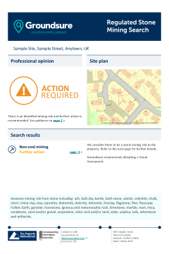
The Groundsure Review combines the most recent and detailed contamination and flood risk data to provide a comprehensive risk assessment. Designed with improved conveyancer work flow in mind, issues and clear next steps are easier to identify, with revised data order and better sign posting resulting in more logical, easy to follow reports.
What does it cover?
- Details on whether the site represents acceptable banking security from an environmental risk perspective
- Full contaminated land risk assessment covering essential Part 2A requirements
- Full suite of digitised data based on 1:500, 1:2,500 and 1:1,250 scale historical mapping
- Detailed flood risk opinion including river, coastal and surface water flooding and historic flood events
- Unique Groundsure datasets including historical land use, military and ordnance features
- Environmental Permits, Incidents and Registers
- Detailed active and historical landfill data from authoritative sources, including the Environment Agency, British Geological Survey (BGS), Local Authorities and historical Ordnance Survey mapping
- Current industrial site data
- National Grid gas pipeline and electricity transmission lines
- 1:50,000 scale BGS records for artificial, superficial and bedrock geology
- Geology, Hydrology and Hydrogeology
- Natural hazards including natural ground subsidence and detailed radon potential
This report supports your professional requirements under The Law Society and RICS Red Book and is accepted by all major UK lenders.
Please log in or register if you are interested in ordering this product.

Overview
The report includes detailed environmental data on contaminated land, flood risk, ground stability and geological hazards and utilises a range of datasets to ensure a reliable overview of risk.
The report utilises Groundsure’s unique historical land use database, this features detailed and specific land use information dating back over 175 years. It also contains datasets from trusted data providers including the Environment Agency and the British Geological Survey.
The data is reviewed and an opinion is provided by specialists within Groundsure’s consultancy team, who are on hand to answer any questions you may have about the findings within the Screening report. Environmental insurance is available if required.
What does it cover?
- Historical land use database of potentially contaminative features including garages, petrol sites, tanks, energy installations and military/ordnance sites
- Up-to-date environmental permit, incidents and registers data
- Detailed active and historical landfill data from authoritative sources, including the Environment Agency, British Geological Survey (BGS), Local Authorities and historical Ordnance Survey mapping
- Underground electricity cables and gas transmission pipelines
- Geology, hydrology and hydrogeology
- Designated environmentally sensitive sites including Green Belt, Local Nature Reserves and National Parks
- Ground stability assessment including non-coal mining and subsidence risks
- Coal mining screening
- Flood risk screening uses Environment Agency, Natural Resources Wales, and BGS data
- Additional information covering overhead powerlines and existing and proposed mobile phone masts
Please log in or register if you are interested in ordering this product.
Please log in or register if you are interested in ordering this product.
Please log in or register if you are interested in ordering this product.

|
Overview Groundsure Avista is the ten-in-one environmental report, which condenses results into less than 20 pages, by omitting extraneous data and only returning information relevant to your search. The report now includes full mining and ground stability searches, and planning development extents - as standard. 10 Key Conveyancing searches
Avista Action Alert Having processed location specific results, Avista is able to identify recommended or optional actions. By further analysing the complexity and time it takes to complete these actions, the Avista Action Alert provides a clear score that conveyancers can use to prioritise work at a glance, improve case management and keep transactions moving. Please view sample report and product card for more details. |
Please log in or register if you are interested in ordering this product.